
A house can begin with a hole
A rural homestead in Bangladesh can be read from its highest point: the packed earth beneath the courtyard, the plinth lifted above surrounding fields, the trees holding the slope, the rooms arranged where seasonal water is least likely to reach them. But the more revealing place may be lower. Beside many homesteads sits a pond. It looks like a separate object, a water body added to the domestic landscape. In some cases, it is also the negative space from which the house was made.
That relation is documented rather than merely picturesque. A 2005 handbook on flood-prone rural housing describes homestead raising as an indigenous practice in which a dwelling mound is built with earth excavated from ponds and canals. A 2012 review of pond aquaculture in Bangladesh makes the relationship even more explicit: many households excavate soil to raise the base of their homes to avoid flooding, and the excavation leaves a small pond close to the homestead. The same review linked this process to the creation of borrow pits when new households form.
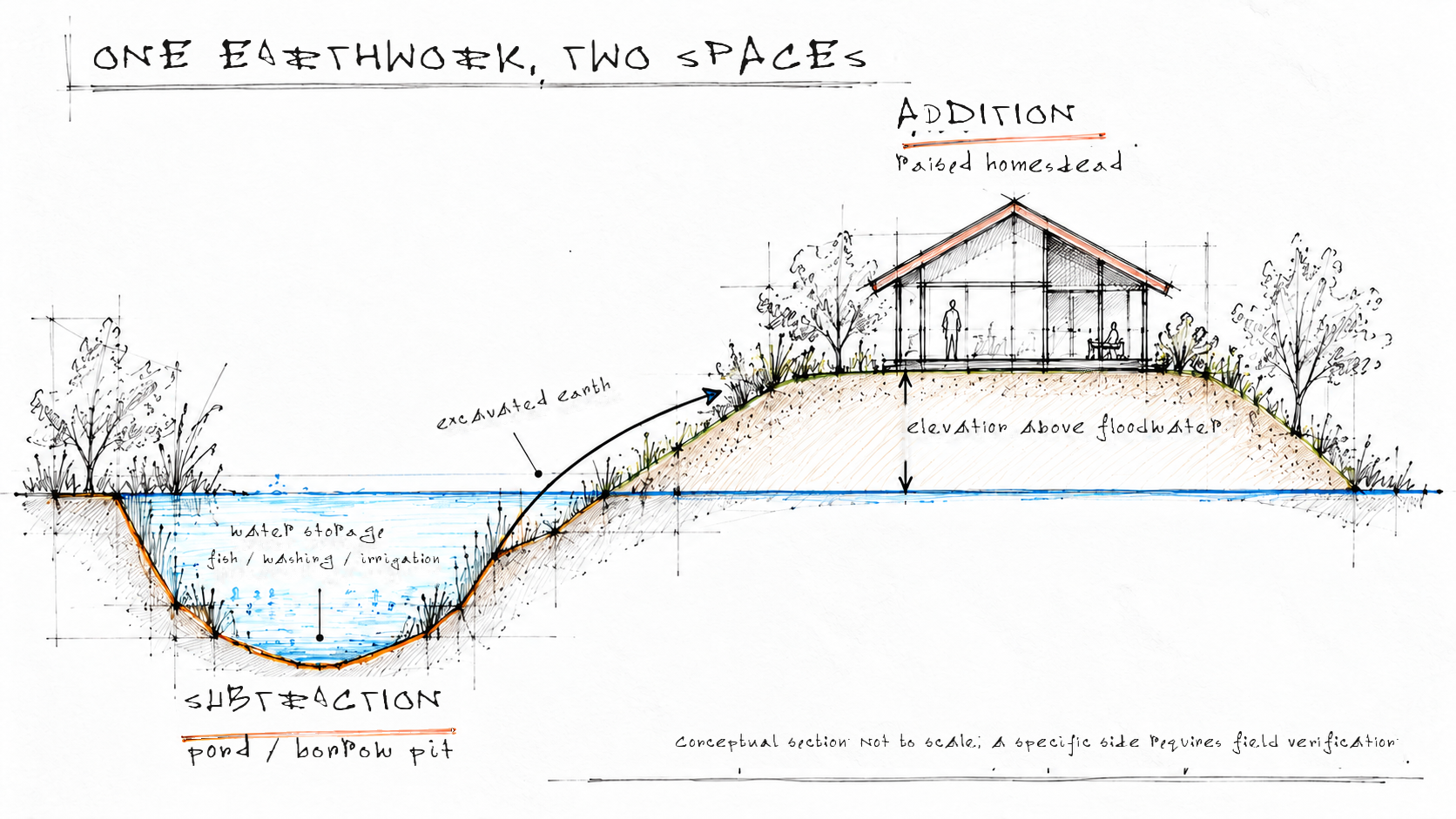
This changes how the landscape can be read. The pond is not necessarily a water feature placed next to architecture. The mound is not necessarily a platform independent of the pond. Under one recurring construction logic, subtraction creates addition. A depression becomes elevation. The land removed from one coordinate becomes habitable ground at another.
One earthwork, two forms
Modern drawings tend to separate these conditions. A site plan gives the house a footprint and the pond a boundary. Engineering quantities place excavation under one line item and fill under another. Landscape and architecture become adjacent categories. The vernacular operation collapses that separation because it begins with material transfer.
Imagine the construction sequence without assigning formal names to its parts. A household needs a higher piece of ground. Soil has to come from somewhere close enough that moving it remains possible with available labour, tools and cost. Excavation produces a void. The void collects water. The fill is compacted into a mound. The mound supports courtyard, trees, livestock, storage and houses. The pond can then serve other functions that outlive the construction moment: fish production, bathing, washing, irrigation or water for nearby vegetation.
Belton and Azad’s 2012 review is useful here because it prevents the pond from being treated as a single-purpose artifact. Homestead ponds are small and frequently multifunctional. Their paper estimates that roughly one fifth of rural households in the HIES 2005 dataset owned such a pond, while stressing that fish culture is often not the pond’s primary function. The spatial form has a biography: first earth source, then water body, then part of a household production and care system.
The first design variable is height
The logic begins with flood level. In a low-lying delta, a few tens of centimetres of elevation can change what gets wet first, how long water remains around a dwelling and whether household goods can be kept above ordinary inundation. The 2005 flood-housing handbook treats land preparation as a design problem in its own right. It recommends that raised ground account for settlement after filling, that loose earth be compacted, that mound edges be stabilized with vegetation, and that slope geometry respond to soil type.
This is local knowledge in a precise sense. The insight is not that earth is a traditional material. It is that the location, height, slope and consolidation of earth decide whether the dwelling ground remains usable when water rises. A homestead mound is therefore not simply ‘higher land’. It is a constructed topography whose performance depends on section.
The pond matters because it gives that section a material origin. The house’s flood advantage is purchased through a nearby lowering of ground. The domestic landscape contains both moves at once. Seen this way, resilience is not located only in the object called the house. It is distributed across a coupled terrain.
The pond does not have one job
The construction argument would be weaker if the excavation became a useless scar. Instead, rural ponds often enter the daily economy of the homestead. The aquaculture literature records bathing, washing, livestock watering, irrigation and fish culture among their uses. A pond excavated partly for fill may become productive water infrastructure after the house has been raised.
That sequence matters because it differs from a design process in which each need receives a separate optimized object. One operation can generate several capacities. Earth provides elevation. The excavation provides storage. The water body can support food, cleaning and cultivation. The surrounding edge may carry vegetation or paths. The outcome is not automatically efficient or ecologically benign, but it demonstrates a form of spatial economy: material movement is made to do more than one job.
A history of Bangladesh describes the countryside as dotted with homesteads around man-made ponds used for domestic water and fish. That wider historical picture does not prove how any particular pond originated. It does show how deeply the pond-homestead pairing sits within the rural settlement landscape. The useful question for A4 is therefore not whether the form is ‘traditional’. It is what operational knowledge the pairing contains.
Do not infer history from appearance
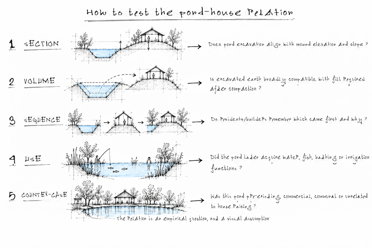
The danger is obvious. Once the pond-and-mound relation becomes legible, every pond beside every rural house starts to look like evidence of the same process. That would be bad fieldwork. A pond may predate the current house. It may have been excavated mainly for fish culture, irrigation, clay, commercial earth sale or communal water. Fill for the homestead may have come from a road cutting, riverbank, dredged sediment or imported soil. A pond may also have been enlarged long after the dwelling ground was established.
The visible adjacency is therefore only a hypothesis. To establish a specific relationship, a field study needs more than photographs. It needs section, construction sequence and testimony. Approximate excavation volume can be compared with the volume of fill required to raise the mound, while allowing for compaction, unsuitable material, erosion and later modifications. Residents, earth workers and builders can help reconstruct what was dug, what was moved, where it went and how the site changed over time.
This is exactly where local knowledge should be treated as evidence rather than atmosphere. An elder’s account of when the pond was cut is not a decorative quote. A mason’s explanation of which soil is suitable for fill is not colour for a story. These accounts can establish sequence, material discrimination and reasons that a map cannot recover. AEDIMEMORA’s own editorial method is explicit that local knowledge must be credited and separated from the editor’s interpretation. The pond-house relation rewards that discipline.
A reciprocal earthwork
A useful way to describe the documented pattern is reciprocal earthwork. The phrase is not offered as an established vernacular term. It names a relationship that conventional categories tend to split apart: excavation and elevation, water space and dwelling ground, landscape and architecture.
The value of the distinction is analytical. It lets a researcher ask whether a project produces beneficial topography twice from one movement of material. It also makes the costs visible. A deeper pond can create dangerous edges. A raised mound can erode. Poorly compacted fill can settle. Water quality can deteriorate. Women or children may carry disproportionate labour associated with water use and maintenance. Floods can still overtop the platform. Vernacular intelligence is not immunity from failure.
Nor should reciprocal earthwork become a recipe to copy literally. Contemporary rural construction now operates with different land prices, mechanized excavation, road access, groundwater pumps, brick and concrete buildings, aquaculture markets and altered flood regimes. In some locations a pond may be undesirable or impossible. The transferable knowledge lies one level deeper: treat excavation, fill, water storage, elevation and later use as a linked system before separating them into projects.
The section before the style
Vernacular architecture is often preserved through images of roofs, walls, courtyards and materials. Those elements matter, but the pond beside the house suggests another archive. Knowledge can survive in a ground profile. It can survive in the fact that one part of a site is lower because another needed to be higher. It can survive in where trees are planted to hold the mound, in where water is kept, and in how a household continues to use the void created during construction.
This is why the relation deserves to be measured rather than admired. Draw the section. Estimate the earth. Ask who moved it. Ask when the pond appeared. Record how its uses changed. Find the non-example where the pond and the house are unrelated. The argument becomes stronger when it can fail.
Then return to the first view of the homestead. The raised house is no longer just a building placed above floodwater, and the pond is no longer just the blue shape beside it. They may be opposite sides of the same construction decision. The house rises because the ground next to it falls.